Traffic Accidents Analysis and Hotspots Identification Using GIS and Analytical Hierarchy Process: A Case Study of Lahore
DOI:
https://doi.org/10.59543/0jft4062Keywords:
Traffic Accidents, Traffic Safety, GIS, Analytical Hierarchy Process, Accident Hotspots, Risk MappingAbstract
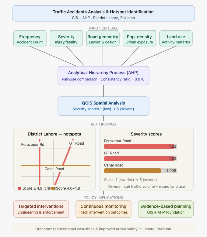
Road traffic accidents are a major health and safety problem in the developing regions. The high rate of casualties annually in Lahore, Pakistan needs to be properly risk-assessed and intervened with safety measures. This paper applies QGIS and Multi-Criteria Decision Making to determine the level of accidents in District Lahore. The Analytical Hierarchy Process uses numerical weights, which represent the frequency, severity, road geometry, population density, and land use patterns, and its consistency ratio is 0.076. GIS classifies the levels of severity between 1 (low) and 5 (severe). Ferozepur Road (4.92), GT Road (4.92), and Canal Road (4.008) become the most dangerous streets since they consistently obtain the highest scores in terms of severity. This has largely been attributed to both high volumes of traffic as well as wide land use along these routes. The results suggest that these places have been causing disproportionately to the accident burden of the district with the consequences being very socio-economic and health-threatening to Lahore. As a way of mitigating these risks, the authorities should immediately join force to roll out specific safety measures, focus on mitigating hotspots that have been identified, and keep track of the results of accidents to ensure their effectiveness. GIS and AHP integration in this study, therefore, offer a strong foundation of evidence-based planning to reduce accidents and casualties.
Downloads
Published
How to Cite
Issue
Section
License
Copyright (c) 2026 Huzaifa Qadeer, Asim Farooq, Danish Farooq, Summera Fahmi Khan, Shahid Noor Jan, Daniyal Hussain, Atta Ullah khan (Author)

This work is licensed under a Creative Commons Attribution 4.0 International License.